


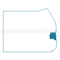
Ophir Voting District, Tooele County, Utah
About
Outline

Summary
| Unique Area Identifier | 680009 |
| Name | Ophir Voting District |
| County | Tooele County |
| State | Utah |
| Area (square miles) | 135.39 |
| Land Area (square miles) | 135.39 |
| Water Area (square miles) | 0.00 |
| % of Land Area | 100.00 |
| % of Water Area | 0.00 |
| Latitude of the Internal Point | 40.33696730 |
| Longtitude of the Internal Point | -112.29071930 |
Maps


Graphs
Select a template below for downloading or customizing gragh for Ophir Voting District, Tooele County, Utah


Neighbors
Neighoring Voting District (by Name) Neighboring Voting District on the Map
- Cedar Fort Unincorporated Voting District, Utah County, UT
- Rush Valley Voting District, Tooele County, UT
- Stockton 01 Voting District, Tooele County, UT
- Stockton 02A Voting District, Tooele County, UT
- Vernon Voting District, Tooele County, UT
Top 10 Neighboring County Subdivision (by Population) Neighboring County Subdivision on the Map
- Lehi CCD, Utah County, UT (74,616)
- Tooele-Grantsville CCD, Tooele County, UT (54,800)
- Rush Valley CCD, Tooele County, UT (941)